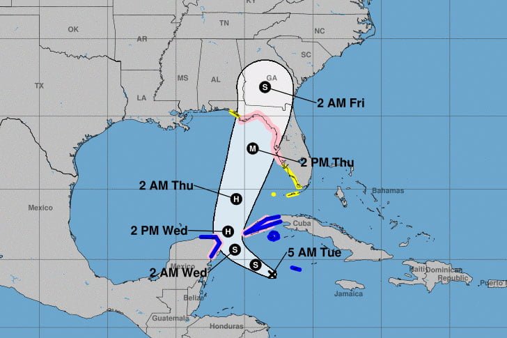
The National Weather Service has issued a tropical storm watch for Orange and Osceola Counties, home to Walt Disney World. Potential Tropical Cyclone Nine, expected to become Hurricane Helene, is currently tracking toward Florida. The National Hurricane Center forecasts the system to strengthen into a major hurricane before making landfall on Florida’s Gulf Coast later this week.
A tropical storm watch indicates the potential for tropical storm force winds (39-73 mph) beginning within the next 48 hours. Based on the current forecast, which shows the storm moving quickly, Thursday carries the highest chance of severe weather for the Orlando area.
Hurricane Helene Storm Details
The system is currently located in the Caribbean Sea and is expected to intensify rapidly as it moves northward into the Gulf of Mexico. Forecasts predict it will become Tropical Storm Helene later today and reach hurricane strength by late Wednesday. The storm could potentially reach Category 3 status or higher before making landfall in Florida.

Potential Impacts on Walt Disney World
While Walt Disney World is not directly on the Gulf Coast, the resort area could experience significant effects from the storm, including:
- Strong winds with gusts potentially exceeding 39 mph
- Heavy rainfall, with 3 to 6 inches possible
- Potential for localized flooding
- Risk of isolated tornadoes
The exact impacts will depend on the storm’s final track and intensity, which are still uncertain at this time. Guests and residents should closely monitor updates over the next 48-72 hours.
Disney’s Response
Walt Disney World has not yet announced any changes to its operations for the upcoming days. However, the resort has comprehensive storm protocols in place. Visitors should monitor Disney’s official website and the My Disney Experience app for updates on park operations.
Looking Ahead at Hurricane Helene
The National Weather Service warns that east central Florida, including the Walt Disney World area, could face potential hazards later this week, particularly from flooding rainfall and strong winds. Forecasters expect the most significant impacts from late Wednesday night through Thursday evening.
As the situation develops, it’s crucial for visitors and residents alike to stay informed and prepared. Walt Disney World officials will continue to monitor the storm closely and make decisions prioritizing guest and cast member safety.
Keep visiting MainGatePass.com for further updates as they relate to Walt Disney World. Always consult local authorities for guidance on watches, warnings, and evacuations.


